Check your boundaries – electorate changes affect Maungakiekie and Mt Roskill1 min read
Reading Time: < 1 minuteThe electorate boundaries of Maungakiekie and Mt Roskill have shifted once again to take account of population increases. This means that some people will be part of a different electorate to the one they were in before, and will be voting for a different MP in the September election.
Each electorate has to have about the same number of people living in it, so that there is equal representation in Parliament. The boundary review takes place after every census, and the proposals are open to submissions from the public.
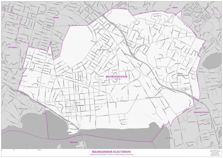
The number of electorates in the Auckland region has increased from 24 to 25. The new electorate is in South Auckland, and its final name, following public consultation, is Takanini. In total, there are 72 electorates in New Zealand– 65 general electorates and seven Māori electorates.
In 2014, when the boundaries last changed, Mt Roskill, (current Labour MP Michael Wood), gained all of Royal Oak, some of One Tree Hill, a portion of Onehunga and a small section of Epsom South. Now, these areas are back in the Maungakiekie electorate, (current National MP Denise Lee). While Mt Roskill has lost this section of population, its boundary has stretched in the other direction, and taken on some of the New Lynn area. The opposite has happened for Maungakiekie, which has lost Point England, Panmure, the area around the foot of Mt Wellington, and the section in north Otahuhu.
The new boundaries are now fixed for the 2020 and 2023 elections. Each parliamentary candidate standing for election will be confirmed in August.
To find out more about your electorate boundary, go to votenz/boundary-review-2019-2020